Yellow-crowned Night-Heron – Jefferson Rd. Pond is now an eBird Hotspot
The Parsippany Yellow-crowned Night-Heron (YCNH) of Jefferson Road Pond is seen either on branches near the pond or under the Jefferson Road bridge. Alan Boyd photographed the YCNH today. Some of his photos are here and here. Alan’s flickr photostream is here.
From Mike Ostrow:
“You never know what you’ll see out of this little corporate pond. The juve Yellow-crowned Night-Heron was in the water between the footbridge and road bridge. When I crossed over the road to look on the other side, a deer came out of thickets, from where I have no idea, crossed under the bridge in the water, and eventually came back. When I went back to the other side, it was clear the deer had flushed the heron out of its hiding area between the bridges and out onto the pond!”
Important note to eBirders: Jefferson Road Pond is now an eBird Hotspot. Please change your personal location to this Hotspot.
Here are the instructions in case you do not know how:
- From your eBird account, go to My eBird.
- Select Manage My Locations from the My Observations sidebar.
- Search for whatever-you-labeled-Jefferson-Road-Pond-as and select it. This will load the Edit Location page.
- Select Merge. You will see a red Hotspot marker for Jefferson Road Pond. Select that Hotspot. Select the Merge button and your checklists from that spot will now be associated with the Hotspot. Your personal location is removed.
This allows anyone to view ALL of the records out of the database for this location in one fell swoop. Please do this as soon as possible. The eBird range map for Jefferson Road Pond is currently a big mess and quickly growing into a bigger mess.
West Morris Greenway – North

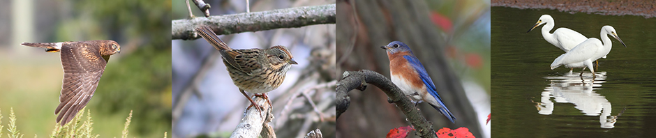
Field Sparrow Family Tree, West Morris Greenway, June 25, 2014 (photo by Jonathan Klizas)
The West Morris Greenway starts at Horseshoe Lake in Roxbury Township, goes south across Righter Road through an easement of the Morris County Municipal Utilities Authority’s (MCMUA’s) property, crosses Pleasant Hill Road in Randolph Twp. and continues, eventually joining the Black River WMA portion of the trail all the way to Pleasant Hill Road in Chester Twp. The northern, or Roxbury/Randolph, section was dedicated in June of 2012.
This post chronicles the northern section through the MCMUA easement. The trail is quite wide (auto road width) and covered with fine gravel. It is completely flat and bordered on both sides by an attractive bottomland deciduous woodland with numerous ferns and other understory plants. There are a few MCMUA dirt roads interrupting the woodland. There is a powerline cut at approximately .75 miles from Righter Road. It is a popular jogging and biking trail so going there early in the morning is best, but there is enough room for everyone.
Bird highlights include 2 singing Northern Waterthrushes (NOWA), one on the south side of the trail opposite the first dirt road on the north side; the second, past the power line near mile marker 4.5. Both NOWA were silent by 8:00 a.m. At least 1 Pine Warbler was trilling in the White Pine grove at the power line. Other species include a flyover Green Heron, Eastern Wood-Pewee, Great Crested Flycatcher, Yellow-throated Vireo, numerous Red-eyed Vireos, Blue-gray Gnatcatchers, Veerys, Wood Thrushes, Ovenbirds, American Redstart, Eastern Towhees, Field Sparrows, Scarlet Tanager, Indigo Bunting, and other typical species.


Pingback: Friday Bird Notes, June 27, 2014 | mocosocoBirds