
eBird Hotspots is a powerful tool for discovering new birding areas and studying data and sightings from familiar locations. mocosocoBirds likes them so much that they will become a regular feature in posts and reports in the future.
This primer also appears under the new Hotspots menu item on the mocosocoBirds web site. A link for the primer is here. Eventually, a menu item for Morris and Somerset County Hotspots will also be included.
This document is a brief tutorial and overview of how to use Hotspots, Hotspot Explorer and Region Explorer.
Table of Contents:
- What are Hotspots?
- Navigating to Hotspot Explorer
- The Hotspot Explorer Interface
- Using Hotspots in Your Observations
- Merging Your Records from Personal Locations into Hotspots
- Region Explorer
- A Note on Sub-locations
- Acknowledgements
Hotspots are public birding locations suggested by eBird users and created by eBird administrators. Using Hotspots, multiple birders can enter data into the same shared location, creating aggregated results available through the eBird interface.
A Personal Location is the other option for entering checklists into eBird. They are created by an individual user and may have data entered only by that user.
The following links from the eBird web site are an informative introduction to Hotspots.
Navigating to Hotspot Explorer
Follow this path to get to the eBird Hotspot Explorer:
- From http://ebird.org/content/ebird/ Select the Explore Data tab. This is the heart of the eBird data reporting interface.
- Select Explore Hotspots. The direct URL is: http://ebird.org/ebird/hotspots.
The Hotspot Explorer Interface
Once in the Hotspot Explorer interface, enter the desired Hotspot in the edit control (a drop-down list of suggestions will appear) or zoom in on the map to find the Hotspot and click on the Hotspot marker. Once the Hotspot is selected, a dialog box appears:
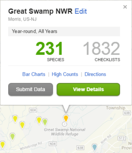
From this screen, the user can perform the following quick links (click on the hyperlinks below to test drive). All data emanates from eBird data. Most of the following reports are available from the Explore Data tab of eBird, but are much easier and quicker to access from the Hotspot Explorer:
- Bar Charts – all recorded species’ frequency of occurrence for this location. The default date parameter is all-time. The user can refine the dates to specific ones of his or her choice (this example link only goes to the main Bar Charts page. Selecting Bar Charts from the Hotspot Explorer goes directly to the Bar Chart for the Hotspot location).
- High Counts – Max numbers for species at this location. Once in this window, the user can refine the date selection or switch to Arrival dates, Departure dates and change the location. It is a very flexible data window.
- Directions – opens a Google Maps window with the marker defining the Hotspot location.
- Submit Data – the user can launch the Submit Observations window with the current location already loaded, assuming the user has a valid free eBird account.
- View Details opens a window represented by the following screen shot:
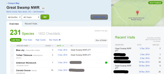
Here is a description of the View Details window:
- Overview is the default tab view and is the most informative.
- Last Seen is the default view for species seen. This can be switched to First Seen which displays the first temporal record of that species in the eBird database.
- High Counts and Bar Charts function as described earlier. Get Directions is the same as Directions.
- Selecting the date of the species record displays the entire checklist for that observation.
- Show All Details displays any comments, links and photographs included by the observer. This can be toggled on and off.
- Recent Visits lists the ten most recent checklists submitted for that location.
- Not visible on the screenshot above, but just below Recent Visits on the sidebar of the page is Top eBirders which, by default, displays a Top 10 list of observers according to the highest life species counts for the Hotspot. This view can be toggled between species and checklists as in other Top eBirder locations throughout the eBird web site.
Using Hotspots in Your Observations
Whether entering a checklist in a browser or via the BirdLog app, the user is eventually faced with the decision of choosing a location.
From a browser:
Select the Submit Observations tab. This displays the Where did you Bird? window. The drop-down list contains the user’s previously used locations. This can be a mix of Personal Locations and Hotspots, depending on the observer’s prior usage.
To specifically find a Hotspot, use Find it on a map. Shared Hotspots are the red marker with the flame (when the map is zoomed out, the red marker may appear with a plus sign, signifying other hotspots are available when the map is zoomed in). Personal locations are represented by plain blue markers without a flame.
[Note: when viewing eBird Species Maps, Red markers with flames signify: “Hotspot – checklist from within the last 30 days”; Blue markers with flame signify: “Hotspot – checklist date is prior to the past 30 days”. Personal locations lack the flame but their color coding has the same temporal significance.]
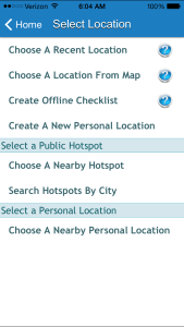
Using the BirdLog app (iPhone or Android – the iPhone version is displayed below):
Select Start New Checklist – the following screen is displayed. Selecting Choose a Nearby Hotspot displays a list view of local Hotspots as does Search Hotpots by City.
Merging Your Records from Personal Locations into Hotspots
Merging your personal locations with existing Hotspots is strongly suggested. The major benefit is that your records can now be included with all the others from the Hotspot and are easily retrievable from the database.
- From your eBird account, go to My eBird.
- Select Manage My Locations from the My Observations sidebar.
- Search for Whatever-you-labeled-the location-you-want-to-merge-from and select it. This will load the Edit Location page.
- Select Merge. You will see a red Hotspot marker for The-location-you-want-to-merge-to. Select that Hotspot. Select the Merge button and your checklists from that spot will now be associated with the Hotspot. Your personal location is removed.
Take Hotspot Explorer to another level and try Region Explorer. This has a similar interface as Hotspot Explorer including views at the county, state, province and national levels.
Sub-locations are defined in the eBird literature as follows: “Sub-locations are smaller scale birding locations found within a larger primary location. These sub-locations are meant to allow more specific data entry for locations found within a larger area of interest” – (from What is an eBird Hotspot).
Sub-locations are an important research tool for designating different habitats and locations within a larger entity. With the first released version of Hotspot Explorer, these sub-locations cannot be aggregated to form a single Hotspot of the entire parent location.
For example: Great Swamp NWR has seven Hotpspots within its borders. Once can view data for each individual Hotspot, but not include all of the data into a Great Swamp overall list. This feature is proposed for an upcoming version of the Hotspot Explorer. For now, use Bar Charts to get the complete picture. Multiple locations can be selected to form a report in Bar Charts (unlike other reports in eBird). For instance, the complete eBird species list of the Great Swamp can be viewed in the link, here.
Thanks to the Cornell Laboratory of Ornithology and the eBird team for creating and maintaining eBird as well as providing information for this article.
Thanks to all the thousands of eBird contributors for creating one of the most impressive collections of data on planet Earth.
Finis


Kudos for another factual, relevant and very useful post! You are amazing!